Explore Owen Sound Like Never Before with New Public GIS Map Online
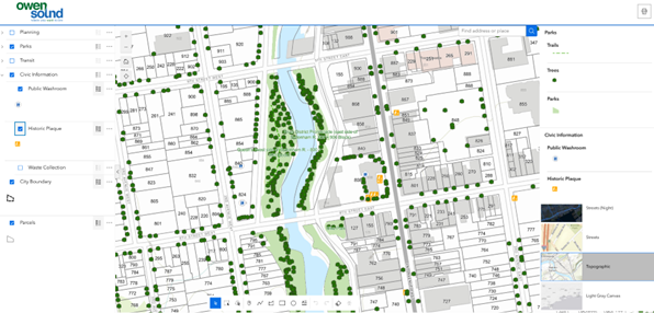
A new public-facing Geographic Information System (GIS) web application is now available through the City of Owen Sound’s website. This interactive tool offers residents improved access to a range of mapped city services and information. It makes it easy to explore a range of city services and infrastructure through information-rich map layers.
Designed for public use, with no private, personal or sensitive information included, the GIS map allows users to view and combine various data layers that the City has compiled. These include:
- Planning application information, such as zoning bylaws, and Official Plan Schedules
- Trails, parks, and city-owned tree locations and related data
- Interactive heritage plaques
- Transit stop locations and Routes
- Waste collection zones and schedules
- Grey Sauble Conservation Authority (GSCA) regulation lands
- Owen Sound Transit bus route maps
The new tool is designed primarily for desktop and laptop use but can also be accessed on mobile devices and tablets. The City is actively working to enhance mobile responsiveness in future updates.
Residents can find the GIS map linked on the City’s website, including a current feature partway down the homepage. Stay tuned to the City’s social media channels and website for more updates and tutorials on how to get the most from the new GIS system.
For more information, please contact Kurtis Boyce, Geomatics Specialist, at 519-376-4440 ext. 1264 or email kboyce@owensound.ca
Quotes:
“This new public-facing GIS map is a practical tool for residents to better understand and navigate their city. Instead of searching through multiple pages or documents, residents can now view detailed, up-to-date information visually on a map, making it easier to find what they need quickly and confidently.”
- Mayor Ian Boddy
Quick Facts:
- There are over 200 layers of spatial information stored in the City of Owen Sound GIS.
- The City has a GIS-based individual tree inventory of over 20,000 trees on City boulevards and within active park areas.
-30-
Contact Us
808 2nd Avenue East,
Owen Sound, ON
N4K 2H4
Phone: 519-376-1440
Email us
Sign up for City news to your inbox!
Stay up to date on the city's activities, events, programs and operations by subscribing to our news posts.